Mapping Public Access in San Juan County
2025
A frequent question that visitors have when seeing a seemingly uninhabited island in the San Juans is whether they are allowed to set foot on a it. Since there is a hodgepodge of ownership and administration in the San Juan Islands — Private, County, State Parks, National Historical Park, National Monument, National Wildlife Refuge — there is no one authority which maintains a map of which islands are accessible to the public. I decided to create such a map and to visit all of the islands shown on it to confirm that they are in fact accessible (there were a few surprises).
By my own count, there are 130 named islands and rocks (not including reefs) in San Juan County. Including unnamed islands, that number is 150. So far as I can discern, 34 of the named islands and none of the unnamed islands have some upland area accessible to the public. Its important to distinguish 'upland' from 'tidelands' here. Many otherwise private islands have public tideland meaning that you can technically show up on the beach on a boat and walk around below the mean high tide line. I do show public beaches, but upland access is the focus of this map.
There are islands outside of San Juan County (Cypress, Strawberry, Vendovi, etc) which are generally considered to be San Juan islands, but the definition gets more contentious the further from San Juan County you go. For simplicity — and to make the task of visiting each of these islands more achievable — I limited the scope of this project to San Juan County.
To confirm the accuracy of this map, I visited all of the islands in person during the summer of 2025. Details from those trips are documented on this page: Accessible Islands of San Juan County.
Making the Map
I made this map in QGIS which is an open source alternative to ArcGIS. I learned ArcGIS when I was in college ten years ago and at the time it was the only game in town. Since then, QGIS has significantly improved, and I can think of no tasks that ArcGIS would have handled better.
Island Outlines
I was not able to locate a landmass dataset to base my map off of — all of the land outline datasets I found for the San Juans were too low resolution for my purposes. I started by merging the San Juan County parcel dataset into one polygon per island and deleting empty spaces, but that was missing many of the smaller islands. I settled on merging both the parcels and the Comprehensive Plan Land Use Data to serve as the base 'island' outlines for the map.
Names
For the names of the islands, I grabbed the shapefile of official US names from the USGS Geographic Names Information System (GNIS). I then cut it down to just the San Juans and deleted duplicate and inapplicable records. I edited the resulting data to add islands not listed in the official names database and to move the location of names for better presentation.
Roads
I realized roads provided some context for locating properties, so I added the county's road center line data.
Public Beaches
The public beach markings come from offsetting selections of Washington State Department of Ecology's Shoreline Public Access Project data away from the beach in question to provide a visually distinct indication of access. I only included numbered public beaches with known access up to the ordinary high water mark. In many cases, I excluded beaches adjacent to publicly owned land to reduce clutter — all of Jones Island, for example, is public, so there is no reason to mark its beach as such. I cross-checked the modern GIS data with information in a 1980's County publication titled "Jan Juan Islands: Your Public Beaches." There was no digital copy of this publication that I could find, so I went to the public library on Orcas Island and scanned the document myself.
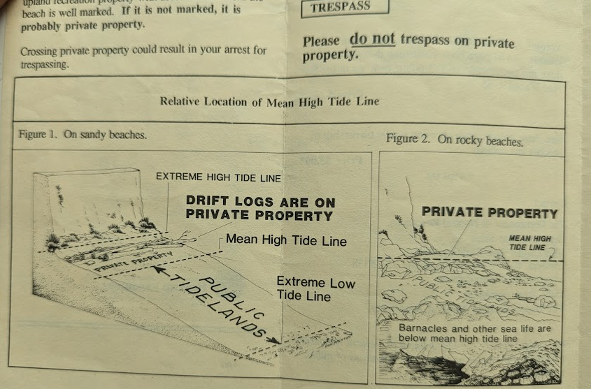
Tideland Description in 1980's San Juan County Publication
Data Visualization
After putting the first draft together with just a binary 'accessible and non-accessible' color coding, I realized I was underutilizing the space available and started to add more detailed land ownership information based on parcel records. The shapefile available for download from San Juan County does not include ownership information, but it is easy to search for specific owners online. I initially was entering stuff like State Parks owned parcels one by one, but I realized that I could select particular parcels based on the parcel IDs returned in the online property owner search. My flow became:
- Search for a property owner online.
- Copy the results to a spreadsheet.
- Copy the column containing the parcel IDs (PIDs) to Visual Studio Code.
- Replace the 'new line' characters with commas.
- Bulk select parcels with those PIDs in QGIS and bulk update the ownership.
Using this procedure, I added County, Washington State DNR, San Juan County Land Bank, and San Juan Preservation Trust land to the map. Many Land Bank and Preservation trust properties are not open to the public, and the Land Bank does not maintain maps showing the entirety of their holdings — likely to discourage illicit public access. San Juan Preservation Trust does maintain a map of their properties. The Land Bank and Preservation Trust are co-owners of several properties; in general, if a property is co-owned, it is marked on the map as being owned by the Land Bank but I can't promise that I was 100% consistent in this delineation.
Final Product
I chose to lay the map out at 11x17" scale so that it would have reasonable detail if it were printed out. With the cropping I chose, a sliver of Cypress Island and Strawberry Island (both of which are in Skagit County, not San Juan County) are within the frame. I chose to suppress these islands since their absence won't cause confusion due to their closeness to the edge.
All named islands in the county are labeled on the map, and all San Juan Islands National Wildlife Refuge and San Juan Islands National Monument islands named or not are shown on the map with colored circles so that they show up even when the islands are small.
Data Verification
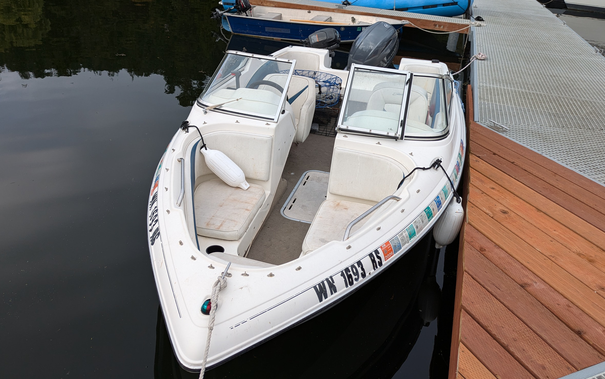
After working at my job for five years, I was eligible to take a one month sabbatical. I chose to spend this time in the San Juan Islands, and my sole 'project' during the sabbatical was to create this map and to visit all of the accessible islands in the county. I was based on Orcas for the month with an 18' Bow Rider moored at Rosario Harbor. I purchased this board in the spring from a friend, and the generally questionable condition of this boat was fortunately well reflected in the price. I had to rip out most of the wiring and replace the fuel system, but there are still lingering issues with fuel delivery at full throttle. Regardless, the front did not fall off and, with various mitigations, it took me to most of the islands.
My trip report of each of the islands can be found here.
The Boat
There are days when the waters in the Salish Sea are as smooth as a Midwestern lake, and it is on those days that I targeted for taking this boat to more distant islands. This boat is basically a lake boat — I have not and may not ever take it to the mainland.
For a few nights of boat camping, I borrowed an aluminum Hewescraft boat belonging to a friend. While it was plenty safe, it surprised me by being an absolutely spine jostling ride. Every wave slapped the hull and transferred directly into the seats. In comparison, my fiberglass bowrider has the mass to cut through waves and only jostles passengers when going through sizable wakes. However, it takes very few waves coming over the bow to get yourself into a dangerous situation. I anchored my boat and paddleboarded to shore to access many of the rocky islands and also, after getting a bit more experience, anchored the boat and then used a second rope to keep it in place at shore to access softer beaches without inflating the paddleboard.
Surprises
- Center Island and Johns island both have undeveloped and unadvertised parcels owned by Washington State Parks.
- Iceberg Island is a publicly accessible State Park Island.
- Cemetery and Gossip Islands have signs indicating that they are day use areas open to the public.
- Guss Island is regarded by the Lummi people as their place of origin in the Universe and is off limits.
- The Whale rocks are privately owned.
Research
Due to the range in ownerships, the sources of truth for which islands are accessible vary. Here are the sources that I relied on prior to confirming access in person.
Islands with County Dock Facilities
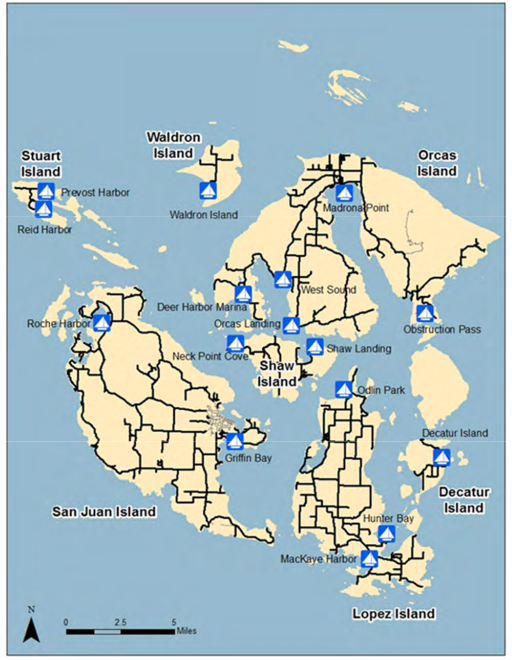
Four of the seven islands with county dock facilities are also served by ferries. These seven islands are:
- Ferry Served
- San Juan
- Orcas
- Lopez
- Shaw
- Not Ferry Served
- Waldron
- Decatur
- Stuart
The ferry served islands are the free spaces on the San Juan County island bingo card. Many residents of the ferry served islands, even if they have lived on the islands for decades, have not been to Waldron, Decatur, or Stuart, though.
State Park Islands
Washington State Parks In and Around the San Juan Islands
Washington State Parks San Juan Islands Brochure
You would think that there would be a central directory of Washington State Parks property along with access rules, but as far as I can tell no such list exists. There are highlights lists, but they don't include all 23 islands with state park properties in San Juan County. By my count, four of these islands with state parks have county dock facilities, 16 islands are entirely owned or leased by the state parks, and three islands are otherwise private with state parks owned property. I emailed the Washington State Parks Information Center about Justice and Iceberg islands and did not receive a reply beyond the first line agent commenting that they had never heard about those properties, so I did not bother asking about their access policies for the other properties. I found 17 of the 23 properties online and found the remaining 6 properties through a search of county property records.
- County Dock Islands with State Parks
- San Juan
- Orcas
- Lopez
- Stuart
- Islands with Adversised State Parks
- Blind Island (Leased from SJINM)
- Clark Island (Part of Sucia Island Marine State Park)
- Cluster Island (Part of Sucia Island Marine State Park)
- Doe Island
- Ewing Island (Part of Sucia Island Marine State Park)
- James Island
- Jones Island
- Justice Island (Parcel part of Sucia Island Marine State Park)
- Matia Island (Leased from SJINWR)
- Patos Island (Leased from SJINM)
- Posey Island (Leased frm SJINM)
- Sucia Island
- Little Sucia Island (Part of Sucia Island Marine State Park)
- Turn Island (Leased from SJINWR)
- Unadvertised State Parks Owned Island
- Cemetery Island (Signage Present)
- Gossip Island (Signage Present)
- Iceberg Island (Signage Present)
- Islands with Unadvertised State Parks Owned Parcels
- Johns Island (No Signage Present)
- Center Island (No Signage Present)
San Juan Island National Monument
At its inception in 2013, the lands of this National Monument were generally open to the public under the unrestrictive 'have fun shooting` rules of the Bureau of Land Management (BLM). Years of deliberation followed and in 2023 a Resource Management Plan was finally certified which significantly restricted public access. Draft Resource Management Plans, for example, permitted camping at McConnell Rocks, but the final plan prohibits access completely. An advisory committee created for consultation in the creation of the Resource Management Plan was disbanded for having served its purpose in December 2023, and a new committee was formed in 2024 which was again disbanded as part of the 'Department of Government Efficiency' cuts of the second Trump administration in 2025. Currently the monument has two staff members who are reliant on Washington State Parks boats to administer the islands.
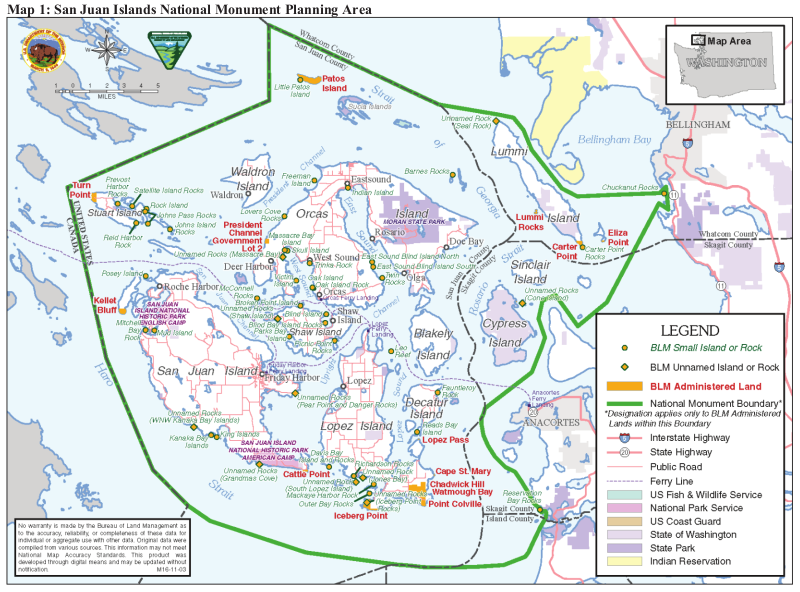
Official SJINM Map
The 2023 Resource Management Plan allows for public access to only nine otherwise inaccessible islands:
- Blind Island (Leased to Washington State Parks)
- Freeman Island
- Henry Island
- Indian Island
- Patos Island (Leased to Washington State Parks)
- Posey Island (Leased to Washington State Parks)
- Reeds Bay Island
- Skull Island
- Victim Island
Admittedly, the monument also includes a fair amount of land on islands with county dock facilities, but the majority of the distinct islands within the National Monument are off-limits:
"Because of their sensitive cultural and ecological resources, the BLM will allow public access only for authorized scientific, educational, and cultural uses in areas of the Monument not designated as RMAs. These areas encompass a total of 29 acres of small islands and 10 acres of rocks. These rocks and islands include formally identified marine mammal haulouts (Jeffries 2000), seabird nesting sites, sensitive plant communities, and Coast Salish cultural sites. Specifically, the small islands are Toad Island, Fauntleroy Rock, Little Patos Island, Lummi Rocks, McConnell Rocks, Mud Island, Oak Island, Parks Bay Island, Richardson Rock, and Twin Rocks. The rocks and groups of rocks are: East Sound Blind Island South, Kanaka Bay Islands, King Islands, Massacre Bay Rocks, Richardson Rocks (2 smaller rocks), Trinka Rock, Chuckanut Rocks, Davis Bay Island and Rocks, East Sound Blind Island North, John's Island Rocks, John's Pass Rocks, Leo Reef, Lovers Cove Rocks, MacKaye Harbor Rocks, Mitchell Bay Rocks, Oak Island Rock, Outer Bay Rocks, Picnic Point Rocks, Prevost Harbor Rocks, Reid Harbor Rock, Reservation Bay Rocks, Rock Island, Satellite Island Rocks, Unnamed Rocks (Grandma's Cove), Unnamed Rocks (Iceberg Point Rocks), Unnamed Rocks (Jones Bay Rock), Unnamed Rocks (Pear Point and Danger Rocks), Unnamed Rock (Seal Rock), Unnamed Rocks (Shaw Island), Unnamed Rocks (South Lopez), Unnamed Rock (WNW Kanaka Bay Island)."— San Juan Islands National Monument Resource Management Plan
References:
San Juan Islands National Wildlife Refuge
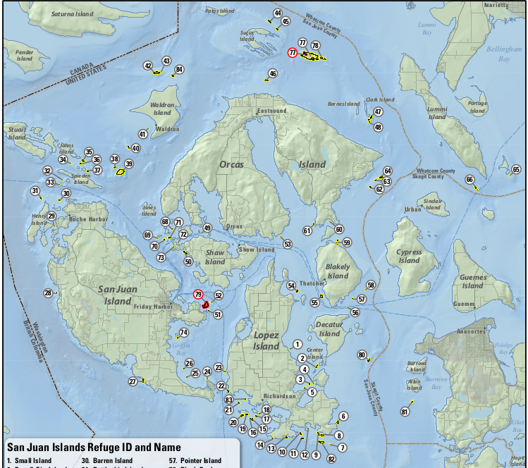
SJINWR Map from the Comprehensive Conservation Plan
The only islands within the San Juan Islands National Wildlife Refuge that are open to the public are Turn Island and Matia island which are both leased to Washington state parks:
"Because of the limited availability of the habitat preserved and the intent to provide an undisturbed haven for wildlife, all but Turn and Matia Islands are closed to public use."— Rocks, Reefs, and Islands within San Juan Islands National Wildlife Refuge
References:
- Protection Island and San Juan Islands National Wildlife Refuges Comprehensive Conservation Plan and San Juan Islands Wilderness Stewardship Plan
- Rocks, Reefs, and Islands within San Juan Islands National Wildlife Refuge
Private Islands with Public Access
Blakely Island is privately owned (aside from some DNR parcels that I did not visit) and has a public dock and general store. Yellow island is owned by the Nature Conservancy and permits visitors to walk around the island. On the map, I put the islands with undeveloped State Parks parcels (Center, Johns, Justice) and Henry Island (which has an Juan Islands National Monument and public access San Juan Preservation Trust land) into this category as well.
Private Islands Without Public Access
I am bothering to list these out to differentiate them from publicly owned islands without public access. None of the upland areas of these islands are accessible unless you are an owner or if you have permission from an owner. These six islands are subdivided between multiple private owners. There are public tidelands along at least some portion of all of these islands aside from Obstruction which has entirely privately owned tidelands.
- Pearl Island
- McConnell Island
- Brown Island
- Crane Island
- Frost Island
- Obstruction Island
There are additionally 26 truly private (at least the upland portion) single owner islands (and two private rocks) within the county. As far as I can tell, no two islands have the same named owner. While owning your own island seems like a cool idea, they are terribly inconvenient to get friends and materials to, and get you a lot less bang for your buck compared to a waterfront property on one of the larger islands. Unless you own Spieden, none of these islands have airstrips, so when the weather is too poor for seaplanes to fly the only way to get to them is by private or chartered boat. With the exception of Trump, at least some portion of the tidelands around each of these islands is public. That means that you could show up in a boat at low tide and walk around below the mean high tide point, but you had better consult the San Juan County Aquatic Parcels map and be prepared to get into a shouting match before doing so.
- Alegria (AKA Little Double): Private LLC
- Armitage: Private LLC. Development prohibited by conservation easement
- Barnes: Private LLC
- Bell: Private LLC
- Big Double: Private LLC
- Cactus (the east one): Private Family
- Cactus (the west one i.e. Little Cactus): Private LLC
- Canoe: Canoe Island French Camp
- Charles: Private LLC
- Cliff: Private LLC
- Coon: Private Individual
- Deadman: The Nature Conservancy
- Dinner: Private LLC
- Goose: The Nature Conservancy
- Harnden: Private Couple. For sale at $0.9M as of 11/2025
- Long: Private Family Limited Partnership
- North Finger: Private LLC
- O'Neal: Private LLC. Development beyond the current cabin and dock is prohibited by conservation easement
- Picnic: Private Individual
- Ram: Private LLC
- Reef: San Juan Preservation Trust
- Satellite: YMCA of Greater Seattle
- Sentinal: The Nature Conservancy
- South Finger: Two private individuals and a conservation trust which shares their mailing address.
- Spieden: Private Corporation
- Trump: Private LLC. Not owned by Donald Trump
- Whale Rocks (the east one): Private Individual
- Whale Rocks (the west one): San Juan Preservation Trust
This list excludes tied islands e.g. islands which are connected to land at low tide.